About ITA-Computations
ITA-Computations is a Powerful cross-platform geospatial app designed for land surveying and engineering professionals as well as students. It provides advanced computational tools for coordinate processing. Whether you're computing bearings, distances, areas, or generating detailed sheets, ITA-Computations has you covered.
Features
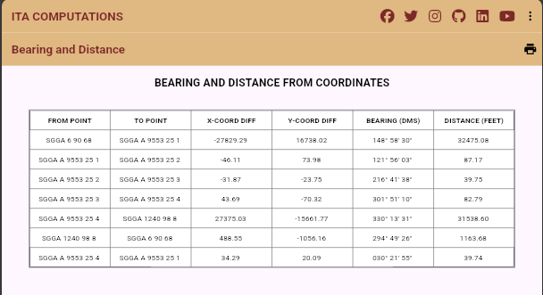
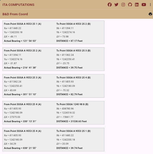
Bearing and Distance Calculation
Compute bearings and distances between coordinates with ease
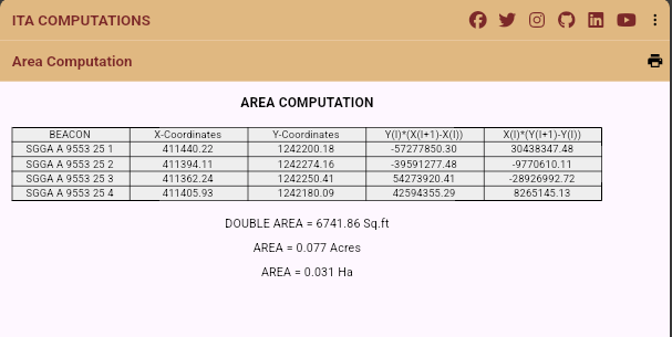
Area Calculation
Calculate areas from coordinates and generate detailed computation sheets
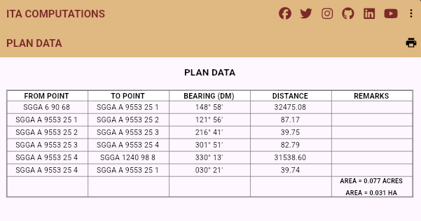
Sheets Generation
Generate Bearing and Distance sheets, Plan Data sheets, and Beacon Index sheets
Light and Dark Modes
Switch between themes for a comfortable viewing experience
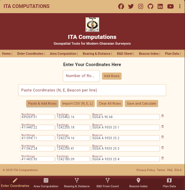
CSV Import
Supports import of coordinates from CSV files for quick calculations
Offline Functionality
Use the app anywhere, anytime—no internet required
Cross-Platform Support:
Available for windows, Android and iOS. Scroll down for download links.
Screenshots
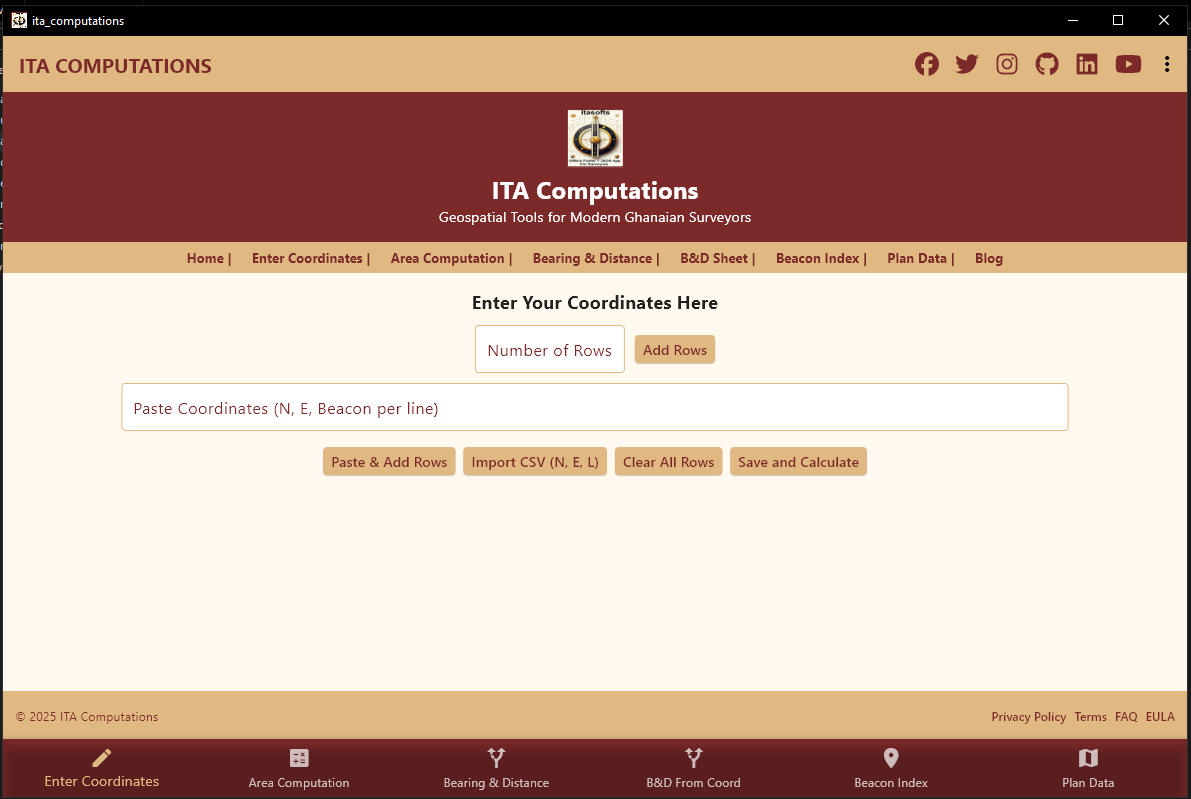
The Main Screen with Coordinates Import
Area Computations
Compute bearings and distances between coordinates with ease with Table Format
Compute bearings and distances between coordinates with ease with Known sheet Format
Generates Plan Data Sheet with ease
Generates Beacon Index Sheet with ease
Getting Started
The Web version works for all platforms (Chrome, Edge, Safari, Firefox). The native apps will soon be available offline for Android, iOS, and Windows.
Geospatial Tutorials
1. Importing SUR Plugin Into AutoCAD
Watch: SUR Plugin Installation Walkthrough
- Open the folder where AutoCAD is installed and browse to the support folder, example C:\Program Files\Autodesk\AutoCAD 2018\Support
- Copy and Paste all the files in the SUR OR JOECAD folder into the support folder and close it
- Open AutoCAD as an Administrator
- Type Menuload in AutoCAD and press Enter
- Click Browse to navigate to the Support Folder and open it
- From the files of type Menu, Select Legacy Menu Files (*.MNS*.MNU) to show the Menu files. Select JoeCad and Click open and close the menuload dialogue
- Go to Customize Quick Access Toolbar Arrow and Select Show Menu Bar to show all the menus including the SUR Menu
2. Creating CSV Files in Excel
Watch: CSV Creation Tutorial
- Open Excel and create columns: Northings, Eastings, Label
- Enter your survey data (e.g., 34567.891, 12345.678, 'Boundary Corner')
- Save as CSV (Comma Delimited) format
Northing,Easting,Description
34567.891,12345.678,Boundary Corner
34612.345,12378.901,Tree Location
3. Importing CSV into AutoCAD Using SUR Plugin
Watch: CSV Import Tutorial
- In AutoCAD, Go to SUR Menu
- Select Point Plotting
- Enter password and click Ok
- Select CSV file from the directory and click Open
- Enter Absolute Point size, Text Size and Offset Distance of Text, for example 12 Inches or 0.3m respectively
- Choose File Format. Choose according to the format of your CSV file (Northings, Eastings, Label) N,E,L and click Ok to view the points in AutoCAD.
- Zoom In and Zoom Out using the Scroll of the mouse to connect the points with a line command.
4. Creating Bearing and Distance for your site plan in AutoCAD using Sur Plugin
Watch: Bearing/Distance Tutorial
- In AutoCad Select line command and connect all your points in a clockwise direction according to your traverse
- In AutoCAD, Go to SUR Menu and Select Bearing And Distance(ft) or (m)
- Type LR for Left to Right and press Enter
- Enter Text Height and press Enter
- Reverse the Bearing Direction (Yes or No): type N for No and Enter
- Select all the lines for the Bearing and Distance and press enter to generate the bearings and distances on the lines selected
5. Creating Grid Lines and Grid Text for your site plan in AutoCAD using Sur Plugin
Watch: Grid Lines Tutorial
- In AutoCAD, Go to SUR Menu and Select Grid Plotting
- Select lower left Corner about 1000 feet to South-West of the plot
- Select Upper Right Corner about 1000 feet to North East of the plot
- Select Grid lines and enter 1000 for Grid Spacing and click Ok
- Enter label Text height for example 20. zero for decimal places and select any color forText Color and click Ok to generate Grid lines and Grid Text
What does this app do?
This app helps you perform various geospatial calculations, including computing bearing, distance, and area from coordinates.
How do I compute bearing and distance?
Enter the coordinates for Point 1 and Point 2, then click "Save and Calculate" to get results.
Can I compute area from coordinates?
Yes, enter the boundary coordinates and click "Save and Calculate" to compute the area.
How do I switch between light and dark mode?
Open the menu and select "Toggle Dark Mode" to switch themes.
How do I download the app?
Select "Download Android Version", "Download iOS Version", or "Download Windows Version" from the menu.
Can I import coordinates from a CSV file?
Yes, click "Import CSV (N, E, L)" and ensure your file includes Northing (N), Easting (E), and Labels (L).
How do I clear all entered coordinates?
Click "Clear All Rows" to remove all input data.
How do I save my calculations?
Click "Save and Calculate" to generate computation sheets.
Can I share the generated sheets?
Yes, you can save them as PDFs or print directly from the app.
How do I contact support?
Reach out via:
- Facebook: [https://web.facebook.com/itettehapotey/]
- LinkedIn: [https://www.linkedin.com/in/isaac-tetteh-apotey-67408b89]
- Twitter: [Your Twitter]
- Instagram: [https://www.instagram.com/life2allsofts/]
- GitHub: [https://life2allsofts.github.io/]
- Email: [https://life2allsofts@gmail.com]
Can I use this app offline?
Yes, the app works without an internet connection.
What units does the app support?
The app supports Meters, Feet, Acres, and Hectares.
How do I update the app?
Updates are available on Google Play, App Store, and the website.
What if I find a bug?
Report issues via GitHub or email us at [Your Support Email].
Can I customize the generated sheets?
Customization options may be added in future updates.
How do I suggest new features?
Share your ideas via social media or GitHub.